Starting January 1, 2026, the gINT software will no longer offer support or updates. For many companies, this is the ideal opportunity to improve and standardize their management of geotechnical and geoenvironmental investigation data.
At Sobek, we are committed to the success of our clients. With over 30 years of experience, we continue to be a trusted reference, committed to the long-term development of Geotec and providing high-quality technical support to our clients.
Geotec is a comprehensive geotechnical data management software, including borehole, lab tests and instrumentation data, profile views, and 3D modeling.
Importance of Data
Data management within a company is a key asset to its efficient operation. Whether it is to access past projects or to track ongoing projects, centralizing data is essential.
From the very beginning, Sobek has always believed in the importance of centralizing project data in a single location. That is why Geotec modules are built around a standard-structured database – owned by the client – and where the data is the priority.
All of your data is accessible from any module and can be utilized for queries, analyses, or graphic reports. For example, you can generate laboratory reports from raw measurements in Lab, then display the calculated test results in the borehole reports via Log.
The security and confidentiality of your projects remain a top priority. With Geotec, you retain full control of your data, which is your property. You have complete access to it, anytime, without having to pay or request permission. To accommodate various corporate setups, Geotec supports multiple database management systems such as SQL Server, MySQL, MS Access, Oracle, and SQLite.
Importing gINT Data into Geotec
We understand the importance of data! That is why we added a feature to Geotec to import data from gINT files. This way, you will have access to all your drilling data history in one place. Having data that already provides an understanding of the subsurface conditions will help optimize future campaigns.
Following are the steps to integrate data from gINT file(s) into your Geotec database.
- From any Geotec module, select the gINT import via File menu > Import from > gINT Project.
- Select the files to import. In the top left rectangle, click the “…” button to browse to the location of your files on your computer. All *.gpj files will be listed in the table below.
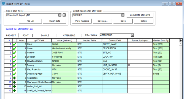
- Choose the mapping to use via the top right rectangle. If none has been previously defined, DEFAULT will be used. The mapping defines the correspondence between the gINT fields and those of Geotec.
- Select a file from the bottom table and click on “View Content”. This file will be used to illustrate and, if necessary, modify the mapping between gINT fields and those of Geotec.
- To map:
- All fields found in the PROJECT and POINT tables are listed in the first two tabs.
- For sampling, Geotec automatically maps the SAMPLE table if found. Otherwise, click the third tab and select a different table name from the dropdown list.
- Mapping for all other gINT tables is done by clicking on the OTHERS tab and selecting the table to map from the dropdown list. A table name displayed in red indicates that it is empty.
- The Value column shows the value of the first record, for reference only. You can view other values from the gINT project using the dropdown list in each cell of that column.
- For each gINT field, use the dropdown lists to select the corresponding Geotec table and field. If a field does not need to be imported, leave the Geotec field empty.
- You can also insert a specific value into a Geotec field using the Dummy row, by specifying the value in the Format column.
- If rows are displayed in red in the table, it means they do not exist in the project selected. You can delete them or adjust the mapping.
- Next, save the mapping by clicking “Save As” to define a new one, or “Save” to overwrite the existing mapping.
- At any time, click “View Mapping” to see the complete list of mapped fields.
- Once the mapping is validated, click “Import Data” to import the data from the current file. You can also return to the file list and select multiple files for batch import. It is important that the selected files have a similar structure to ensure their data is imported using the same mapping.
This mapping work is saved in your corporate database. Each defined mapping can be reused for future imports. Since gINT projects do not all have the same structure, you may need to create multiple mappings. However, you can select an existing mapping, make a few adjustments without starting over, and then save it separately.
In addition to importing data into your Geotec database, other options are available to support gINT projects.
- Open a gINT database from the Log module (.gpj) to view project data through a simple query.
- Generate a gINT style file (.gsf) by converting a Geotec style with the desired mapping, and modify it as needed.
- Visualize the data from a gINT database in Log using a .gsf style.